This OLD POST has inaccuracies, but I’m leaving up for archival purposes. PLEASE USE NEW POST ONLY.

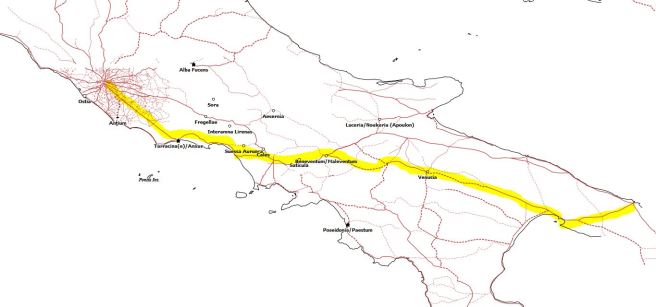
I generated this map and list of find spots based on Burnett and Molinari 2014, Burnett 2006, and Burnett 1977. Below is the list of locations. I don’t claim this is complete, but it is certainly a useful way of visualizing the data for a historian. Compare this to the map of the Via Appia and Colonization in the late 4th early 3rd Cent. Bear in mind the road was not built all at once: to Capua (312BCE), prolonged to Venusia (291), Tarentum (281), finally Brundusium (264).
These are maps made by others (mine above leaves some colonies out):


My first reaction to seeing these three maps is that the coinage is generally found further south and east on the pennisula and does not nicely map onto late 4th century colonization and only slightly better correlated with early 3rd century colonization, but after drawing my own map that combined colonization and the via Appia, I’m happier to see all three as a combined effort.
On the whole the distribution of the coinage seems better correlated with the area surrounding of the via Appia. I want to map pegasi finds in main land Italy next…
| Baselice | 1 |
| Rocca S. Felice | 1 |
| Teano | 2 |
| Foggia | 1 |
| Campobasso (x 2) | 5? |
| Gattaiola, Romito Pozzuolo | 1 |
| Ponte Gini di Orentano | 2 |
| Sulmona | 1 |
| Benevento | 3 |
| San Martino | 3 |
| Torchiarolo | 1 |
| S. Giovanni | 6 |
| Oppido Lucano | 1 |
| Fallani | 3 |
| Mesange | 2 |
| Valesio | 2 |
| Campania(?) | 4 |
