“When I mapped findspots for #NotAllElephants I used “Find spots taken from Vecchi 2014, pp. 29-31 with the addition of Lavinium, Sutri, Viterbo, and the region north of Naples.”
I’m worried I might have missed the following find spots from Garrucci’s list, but they could be listed in Vecchi under another place name!
Ardea (area of the Rutules)
Tarquinii
Fabbro near Orvieto
Fiesole
Now if I’d mapped in Google Earth this would be much more simple to reconstruct and check. Doh. I’m going to leave the question for today, but definitely want to circle back and follow up.
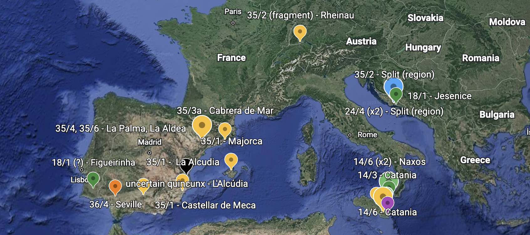
I was collecting bibliography yesterday and was impressed with the running theme of specimens found outside Italy. The Croatian finds don’t surprise me too much because of the Mazin hoard with its roman currency bar fragments (so called aes signatum, see #NotAllElephants). I’d tentatively relate the fragmentary nature of the find in Switzerland to a similar phenomenon. Martínez Chico is right to emphasize the military camp finds at La Palma from the Prow series and events of 2nd Punic War to explain eastern Iberian find patterns and I’d transfer that logic to all the yellow dots in Sicily. The green dots (series 14 and 18) on the Sicilian eastern coast remind me of the patterns noted by Jaia and Molinari 2011, i.e. the association of these early series with the fortification of the Tyrrhenian seacoast line.
The nice thing with building this sort of representation in Google Earth is I can keep adding to it as I come across more references.
ILL still hasn’t given up any treasures as of yet.
The other thing from this morning of note is that the Portuguese variant of RRC 18/1 has Apollo facing left on both sides. I’m concerned however that I don’t understand Martínez Chico assertion that there are two already known variants, A and B. As far as I can tell this is just about the photographer’s choice, but maybe I’m being dense….
It is demoralizing to see the same things on my to do list as yesterday. It isn’t that I didn’t do any of the things, I touched them all. It’s just they all need to be touched again. As is the nature of the work. Progress is the key.
Today
First steps on Aes Grave project – collect more bibliography
More Italy visit logistics
More AAH logistics
Book flights
More BM communications
Schaefer follow up
follow up with Lafayette
Not Today (but maybe tomorrow, or the day after)
Teaching requests for Fall 2023
Circle back to department about any Jan planning meetings
Set time table for any collaborative RRDP work/publication prep that needs to happen this semester: Chicago pub, INC pub, collaboration with RACOM, etc…
Circle back to Capito project
Consider ask for funding from Dean’s office
Begin Med school rec letter
record mini myth
find out what is on that v old harddrive and back up to cloud
Mapping functionality is being increasingly incorporated into digital numismatic publications. The flash maps of the provincial mints were pretty hot stuff when they first came out on the RPC IV website about 8 years ago. They still look pretty good if you ask me. The ANS has started putting maps into most of its sites, the most impressive being the map feature of CHRR online. But sometimes you want more than one point plotted on a map and you want to choose yourself which points are plotted. I was pretty happy with the functionality of AWMC: À-la-carte map. I think my internet speed (DSL) made it a bit clunky or maybe it’s the new Turkish internet security initiatives slowing things down. That said, still worth it. My first simple test (featured above) was to put on a map the mints that produced coins that are hoarded with RRC 13/1. I couldn’t get Cumae on the map at this magnification and use full name labels. It’s label and that of Neapolis overlapped. It however does let you custom label points or just number each point to stop the overlap feature. I then just used the snipping tool (like a screen shot) to grab the portion of the map I wanted.
I suspect this mapping program is going to figure heavily in my lesson plans in future semesters.
For modern locations, such as find spots, there are a number of websites, Multiplottr is simple enough. [Why, oh why, has it become cute to name websites leaving out the last ‘e’?!] Here are the results from plotting, S. Giovanni Ionico, Torchiarolo, Oppido Lucano, Mesagne, Valesio, and ‘Campania’. Not publication worthy but certainly good enough to think with. Very fast and easy to edit.